DHA Margalla Enclave Location & Map — Where It Really Is
Not at the foot of the Margalla Hills — Zone IV on the Jinnah Avenue corridor, near Chak Shahzad. Access and the underpass status, the 'site office number' trap, and why no pre-ballot plot map exists.
By Muhammad Hasnain7 min readVerified 24 August 2026
Short answer: Exact site coordinates from the government EIA, ME-1 to ME-4 zones, Jinnah Avenue access and Park Road underpass status. Not at the Margalla Hills.
Direct line: Muhammad Hasnain, plot specialist for Bahria Enclave & DHA Margalla Enclave — WhatsApp 0300 0399322. Verified before you pay; drawbacks in writing.
Start with the correction nobody else prints: DHA Margalla Enclave is not up against the Margalla
Hills. The “Margalla” is branding. The project sits in CDA Zone IV on the Jinnah
Avenue (formerly Kuri Road) corridor — the same belt as Bahria Enclave, Park View City and Park
Enclave, near Chak Shahzad and Bani Gala. If you pictured pine slopes, adjust; if you wanted a CDA-partnered
address on a widening arterial minutes from the city’s growth corridor, this is exactly that.
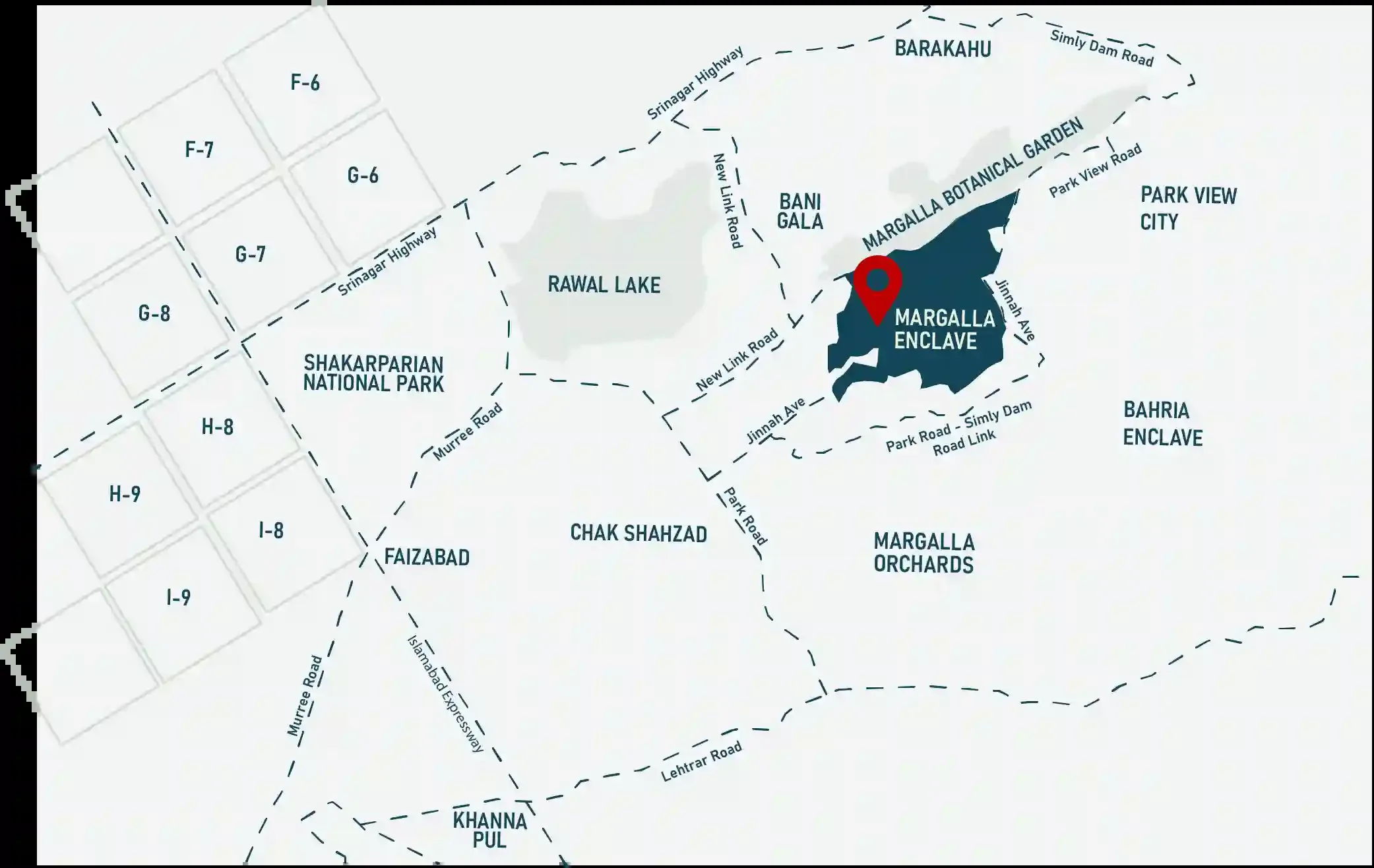
DHA’s own location map — source: official Margalla Enclave
portal (margallaenclave.dhai-r.com.pk), fetched 28 Aug 2026. Read it like a buyer: the named neighbours are
Bahria Enclave, Park View City and Margalla Orchards; the roads that matter are Jinnah Avenue, New Link Road and
the Park Road–Simly Dam Road link; and the Margalla Hills do not appear — the adjacent green band is
the Margalla Botanical Garden reserve, which is where the name borrows its scenery.
Also on this corridor, and constantly confused with it:
Margalla Orchard on Main Park Road opposite COMSATS — a different scheme with a different
sponsor (FGEHA and the Supreme Court Bar Association; DHA joined only in Sep 2025).
The two, compared — and unlike Margalla
Enclave, the Orchard’s full approved layout plan is public and we
digitised it.
Access, honestly dated
The approach: via the Jinnah Avenue corridor and Park Road network on Islamabad’s
south-east side — the same connections our
Bahria Enclave distances table maps, a few minutes further along
the corridor.
The underpass everyone googles: the Park Road underpass and Jinnah Avenue widening directly
serve this approach. Status: it missed its 30-July-2026 target, but ProPakistani (18 Sep) and Islamabad Scene
(20 Sep 2026) both report it open to traffic — see the dated
timeline. Not confirmed: whether the rest of the wider Park Road package is finished.
Why the corridor matters more than the hills: balloting, instalments and eventual possession
all price off access. The 2nd ballot ran at Jinnah Convention Centre in November 2025; the corridor IS the
project’s location story.
“Site office” — read this before you call a number from an ad
Searches for “Margalla Enclave site office contact number” mostly land on dealer ads wearing
official costumes. The rule: anything that matters — ballot status, payment schedules, refunds,
transfer — verify only through DHA Islamabad-Rawalpindi’s official channels (dhai-r.com.pk and its
Margalla Enclave portal), or in person at DHA’s own offices. A “site office” number on
a classifieds listing is a dealer’s desk, not DHA’s. We are dealers too — the difference is we
say so, and we put verification against the official record in writing.
The exact pin — from the government’s own file
Every competing page gestures at “the foothills of the Margalla Hills”. The project’s
Environmental Impact Assessment, filed with Pak-EPA and hosted on
environment.gov.pk, gives the coordinate:
33°41′46.00″N, 73°10′40.58″E. The site sits in
Mouza Kuri and Rehara, reachable from Park Road, Kuri Road, Malot Road and Jinnah
Avenue. The 183-page assessment was prepared for the DHA Islamabad-Rawalpindi – CDA Joint
Venture and the PDF was created on 15 April 2025. We could not find a single dealer site, portal or news
outlet citing it.
How many plots there actually are — the denominator
This is the number every applicant is guessing at. Table 3.1 of the assessment, sourced to the JV itself:
Margalla Enclave plot inventory from the Pak-EPA environmental impact
assessment
Category
Equivalent
Plots
Residential 25′×45′
125 sq yd / 5 Marla
1,709
Residential 35′×65′
~250 sq yd / 10 Marla
2,634
Residential 50′×90′
500 sq yd / 1 Kanal
2,647
Apartment parcels
four footprint sizes
128
Commercial plots
ten footprint sizes
388
Petrol pumps, hotel plot, mega mall
special parcels
4
Residential total
6,990
Grand total, all categories
7,507
There are 1,709 five-marla plots in the entire project. Not per ballot —
in total, across every round, forever. Reported applications for the first ballot alone ran to
roughly 47,000. Whatever you are told about your chances, that is the arithmetic you are actually playing.
Land use against CDA’s own standards
Table 3.2 of the same assessment sets the scheme’s land use beside the CDA planning standards it is
measured against. Total area 10,443.33 Kanal, of which 443.33 Kanal is CDA Zone-IV road, leaving
a round 10,000 Kanal. Two lines fall short of CDA’s minimums — in the
developer’s own submission:
Margalla Enclave land use versus CDA planning standards, from the
environmental impact assessment
Land use
Kanal
Share
CDA standard
Residential (plots, condominiums, parking)
4,506.59
45.07%
50% maximum
within
Commercial (plots and parking)
604.11
6.04%
5% maximum
plots alone 4.91% — at the cap
Public parking
467.00
4.67%
5% minimum
below the CDA minimum
Open and green (parks, nullah, lake)
1,591.86
15.92%
15% minimum
within
Existing graveyard
15.78
0.16%
2% minimum
below the CDA minimum
Roads
2,814.66
28.15%
23% minimum
within
Graveyard allocation is 0.16% against a 2% minimum — about a twelfth of the
standard — and public parking is 4.67% against a 5% minimum. We are not calling
that a scandal; schemes are routinely granted relaxations, and the document is a submission rather than a final
approval. We are telling you it is in the file, on a government server, dated April 2025, and that it is the
kind of question a buyer is entitled to ask before a ballot rather than after one.
Two different “maps” get asked for. The location map exists — DHA’s
official one is reproduced above. What does not exist publicly is a parcel-level plot map
equivalent to Bahria Enclave’s digitised LOP sheet —
allocation runs by ballot on DHA’s master planning, and plot-level positions follow allotment. What you can
and should check today: the official portal’s scheme information, the published
payment plan (now transcribed from DHA’s own portal), and —
after 4 September — the balloting result on DHA’s CNIC
checker. Any dealer PDF “map” showing you a specific plot pre-ballot is decoration, not
allocation.
Distances that matter (corridor baseline)
Use the Bahria Enclave numbers as the corridor baseline — Blue Area ~20–25 minutes on a normal
run, the airport ~40 via the Expressway — and add a few minutes along Jinnah Avenue. Now that the underpass
is reported open, the whole corridor’s times should compress together; that is the infrastructure story both
projects share, and it is why we track it on the news page.
Deciding between the corridor’s two products? Ballot structure vs live resale
market — the full comparison is Margalla Enclave vs Bahria
Enclave. And for the application window closing 4 September 2026:
the ballot guide.
Inventory, both sides of the trade
Plots available in every Bahria Enclave sector — and we buy as well as sell
From Sector A’s finished streets to Sector O’s entry tickets —
5 Marla to 4 Kanal, file to allotment to possession — we keep live options in all sixteen sectors,
plus DHA Margalla Enclave ballots, files and resales. Buying, selling, or exchanging: one WhatsApp message
gets you today’s real options, with verification built in before any token moves.
In CDA Zone IV on the Jinnah Avenue (formerly Kuri Road) corridor — the same belt as Bahria Enclave, Park View City and Park Enclave, near Chak Shahzad and Bani Gala on Islamabad's south-east side. Despite the name, it is NOT at the foot of the Margalla Hills — 'Margalla' is branding; the corridor is the actual location story.
Not publicly — allocation runs by computerised ballot on DHA's planning, and plot-level positions follow allotment. Scheme information and payment plans are published on DHA's official portal; results check by CNIC after balloting. Any dealer 'map' promising you a specific plot before the ballot is marketing, not allocation.
Treat that search with care: most numbers advertised as 'site office' belong to dealers, not DHA. For anything official — ballot status, schedules, refunds, transfers — use DHA Islamabad-Rawalpindi's own channels (dhai-r.com.pk and its Margalla Enclave portal) or DHA's offices in person. Dealers (us included) are for market intelligence and verification legwork, never the source of official record.
Nahi — naam branding hai. Project Zone IV me Jinnah Avenue (purani Kuri Road) corridor par hai, Chak Shahzad/Bani Gala ki taraf — wohi belt jahan Bahria Enclave aur Park View City hain. Pahari manzar ke liye nahi, corridor ki growth aur DHA-CDA structure ke liye liya jata hai. Underpass khulne par yahan ka safar aur behtar hoga — status hum news page par update karte rehte hain.
The third ballot was drawn on 15 September 2026, eleven days after applications closed. How to check your result, what winners pay within 30 days, the official prices — and buying or selling a balloted plot.
Bahria Enclave resale is lump-sum territory — the genuine instalment routes are Margalla's official plan, bank/RDA financing, and seller-financed deals that are only as safe as the checklist you run first.
Websites quote three different '5 Marla prices' for Margalla Enclave — 1.55 Crore, 1.8 Crore, even 2.1 Crore — and none explains why. Here is what each number actually is and which one you would pay.
Direct line
Reading done, decision pending?
Send budget, purpose and timeline. The reply names sectors, not slogans.