Bahria Enclave Location & Map — Where It Actually Is (2026)
Zone IV on the Bani Gala side of Islamabad — how to reach it, what's around it, and the Rawalpindi mix-up that costs buyers money.
Short answer: Live Google map + one-tap directions from your location. CDA Zone IV near Bani Gala via Park Road; distances, underpass status, Rawalpindi mix-up cleared.
Direct line: Muhammad Hasnain, plot specialist for Bahria Enclave & DHA Margalla Enclave — WhatsApp 0300 0399322. Verified before you pay; drawbacks in writing.
The one-line answer: Bahria Enclave sits in CDA Zone IV, Islamabad — the developer's own FAQ places it “near Bani Gala and Park Enclave” — reached via Park Road and the Kurri Road / Jinnah Avenue corridor, with Chak Shahzad roughly 8 km away. Wider access runs to the Islamabad Expressway, Lehtrar Road and the highway network.
Getting there
- From Blue Area / F-sectors: Park Road is the working route — about 20–25 minutes off-peak.
- The corridor itself: Kurri Road — now signed as Jinnah Avenue along this stretch (both names circulate; same road) — carries you past Park View City to the Enclave's entrance belt.
- The underpass: CDA's Park Road underpass missed its 30-July-2026 target but is now reported open to traffic (ProPakistani 18 Sep, Islamabad Scene 20 Sep 2026) — see the dated status & route.
Don't buy in the wrong “Bahria”
Bahria Enclave (Islamabad, CDA, Zone IV) is not Bahria Town Rawalpindi (Phases 1–8, RDA, off GT Road) — they are ~44 km apart with entirely different prices and approvals. Quotes, maps and YouTube videos routinely blur the two. Every figure on this site is Bahria Enclave Islamabad only.
Inside the gate: the zoo (with its white lion), the Grand Jamia mosque, Beaconhouse, the commercial belts and the hospital are covered in our sectors guide — location gets you here; the sector choice decides what the address is worth.
Live map — open in Google Maps for door-to-door timing at your travel hour.
Directions from my location (Google Maps)Looking for the society’s own plan rather than the road map? The digitised Layout Plan (LOP) map shows every sector — and the parcels the plan itself marks as outside the approved LOP.
The approved plan itself
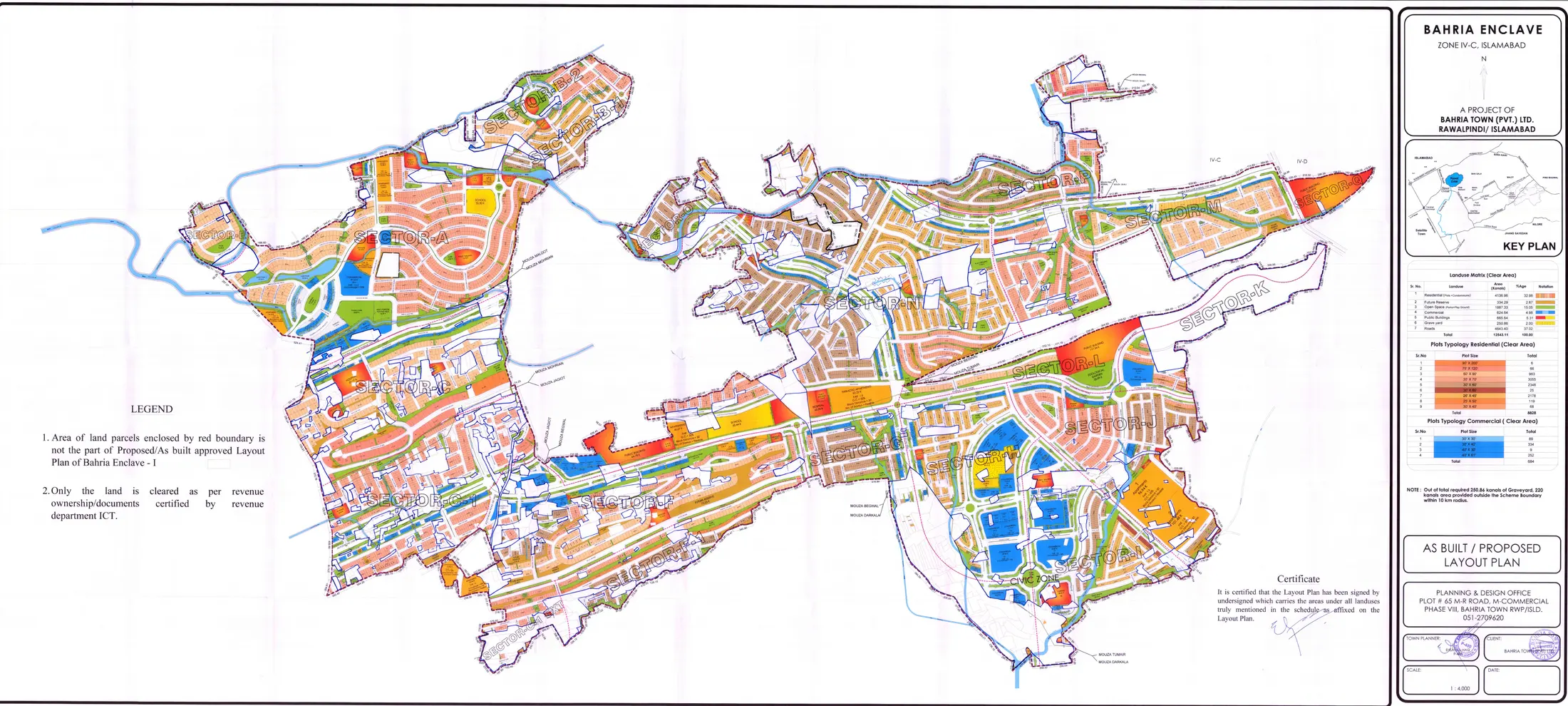
Bahria Enclave on the map, sector by sector
Every pin is a coordinate we could verify: Google Maps’ own sector places, OpenStreetMap for the zoo, and DHA’s EIA for Margalla Enclave. Sectors F, G, H, I, J, K, M, O and P are not places on Google Maps at all yet (checked 3 Sep 2026) — they are on the approved layout plan, not guessed onto this map.
Tap a pin for the sector guide and a WhatsApp line for that sector. Map data © OpenStreetMap contributors. Download the pins (KML) for Google My Maps or Earth.
Distances that matter
| From / to | Distance | Note |
|---|---|---|
| Blue Area (CBD) | ~22 km | 20–25 min off-peak via Park Road |
| F-7 / F-8 Markaz | ~18 km | ~20 min |
| Chak Shahzad | ~8 km | 10–15 min |
| Bani Gala | same Zone IV belt | “near” in marketing terms — budget a proper drive, not a walk |
| Islamabad Int'l Airport (new) | ~58 km | ~55–70 min by expressway |
| Bahria Town Rawalpindi (Ph 1–8) | ~44 km | a DIFFERENT project — see below |
Compiled from public route data, Sep 2026 — approximate and traffic-dependent; verify on live navigation.
Need more landmarks — Faizabad, Zero Point, NUST, Murree, and the one-tap “from my location” answer? The full table lives in the distance guide. Writing the address rather than driving to it: postal code, settled.
Getting oriented
In CDA Zone IV of Islamabad — the developer's own FAQ places it 'near Bani Gala and Park Enclave'. Practically: you approach via Park Road, then the Kurri Road / Jinnah Avenue corridor, with Chak Shahzad about 8 km away. It is inside Islamabad Capital Territory, under CDA — not Rawalpindi.
No — and this mix-up costs buyers real money. Bahria Enclave is the smaller, CDA-approved Zone IV project in Islamabad near Bani Gala. Bahria Town Rawalpindi (Phases 1–8) is the original Malik Riaz development off GT Road, RDA-approved, roughly 44 km away. Prices, approvals and market dynamics are completely different — always confirm WHICH project a quoted rate belongs to.
Roughly 22 km / 20–25 minutes to Blue Area via Park Road off-peak, and about 58 km to the new Islamabad International Airport. Distances are route-and-traffic dependent — treat them as planning figures and check live navigation for your hour of travel.
A CDA underpass on Park Road built to unclog the approach that serves Bahria Enclave, Park View City and DHA Margalla Enclave. Honest status: it missed its 30-July-2026 target, but ProPakistani (18 Sep 2026) and Islamabad Scene (20 Sep 2026) both report it open to traffic. Neither names an inauguration date and we have found no CDA notice — see the dated timeline on our underpass page.
Want to see it, not read it?
Video plot visits run seven days a week — the street, the approach, the neighbours' construction, live on WhatsApp.
Maps, distances and addresses
- Every map, one pageThe approved plan, the live pin-map, the PDF and a sector price legend — the door to all of them.
- Approved layout planCDA’s own plan, digitised — sector by sector, including the parcels it excludes.
- Download the map PDFThe approved sheets as files — no form, no email — and how to read one.
- Distances & drive timesAirport, Blue Area, Faizabad, Zero Point — km and off-peak minutes.
- Postal code & addressWhat couriers actually accept, and why directories disagree.
- Margalla AvenueThe road that decides the drive — status, not brochure promises.
- Living thereSchools, hospital, water, power — day-to-day reality.
- All 16 sectorsCompared on price, development stage and what each is actually for.
- “Bahria Enclave 2”A different scheme in a different place. Do not confuse the two.